

Crete - Out to the Open Sea
- Răzvan Constantinescu
- Jan 14, 2022
- 27 min read

Updated: Mar 4, 2022
[2019, April]
Although I’ve been planning to go to Crete for quite a long time now, I skipped it each time, as it would have been a much longer detour from my past routes than I could really afford. This time though, the island will be the main goal of my tour, which will also include a prologue along the much praised riding routes of the Southern Albanian Adriatic Sea coast. As usual, I don’t need much preparation for the journey, I just book a cabin on the ferry connecting the port of Piraeus to Crete – that is a seven hours long overnight sail, which fits me greatly, as this way I save both time and the price I’d pay for a hotel room – and on 2019’s Good Friday, early in the morning, I set off!
A panoramic route throughout the Western Balkans. 625 miles
Almost each time I set off on a long journey, my first day’s pace is alert and hurried, as I always try to get as far from home as I’m able to. Why? I don’t know and I can’t explain it, but this is what I do this time, too. I plan to reach the Albanian seashore close to the city of Shkodër by taking the most direct route there, which leaves Romania across the newer Danube bridge at Calafat – Vidin, then goes through North-Western Bulgaria, Southern Serbia and Eastern Montenegro, and the only decent accommodation I could find along it – far enough from home, as I’ve said – is in the town of Novi Pazar, in the Serbian province of Raška / the former Ottoman Sanjak, not far from the border to the so-called state of Kosovo. [No offence intended here: considering my family roots, the Albanians are almost brothers to me, yet the ‘Kosovo je Srbija’ syntagm has a strong resonance inside my head nevertheless!]

Google Maps tells me the shortest route to the border town of Calafat goes by the city of Craiova, via Caracal, and it suggests a hilarious way to reach the E70 highway, onto a maze of backroads and even a motorway section, which honestly I wouldn’t have been able to work out without the help of the voice guidance app. Luckily, most of these roads are freshly rebuilt and traffic free, therefore I get to the town of Roşiorii de Vede, just 60 miles short from Craiova, by ten o’clock. That’s been a really good start! Further on, I find my way through the city’s southern outskirts and continue onto the equally free E79 highway towards the border crossing across the “New Europe” Danube bridge, where I arrive half an hour past noon, which is amazingly early compared to what I’ve been expecting to. It seems everything goes smoothly for me today, as both the border controls – the Bulgarian one here and the Serbian one at Vraska Chuka, 40 miles farther – take less than ten minutes each and I’ve also gained an hour on the clock, due to the time zone change.
Once entering Serbia, my next target is the Kopaonik National Park, a mountainous area featuring pristine nature and numerous ski slopes and hiking trails, which is about 140 miles away, so I afford taking my time in order to do some sight-seeing on the way there. I have already ridden a couple of years ago the spectacular road from Zaječar, the first town enroute, to Paraćin, therefore this time I’m not wasting any time admiring the landscape, but instead I try to enjoy the flawless tarmac and the endless wide bends and turns, which really tempt me twisting the throttle. Still, I don’t get too soon to the broad Morava River valley – the main north to south transit route throughout the Balkans, which, followed by the Vardar River valley, connects the Danube to the Aegean Sea, as two local bikers approach me while I’m taking a break in a roadside rest area; looking at the brightly shining chrome on their cruisers, I can tell the guys, well beyond their retirement age, are obviously out for a short leisure ride and it seems they’re also feeling like talking to anybody who’s willing to listen to them :). Although they speak mostly Serbian, we still manage to chat for about half an hour on the universal bikers’ subjects, as motorcycles ridden, roads travelled and so on, then they ride beside me along several miles before waving me good-bye, as they’re surely in no hurry at all.
Further on from Paraćin, I ride towards Kruševac, a dull town which doesn’t tell anything to me, then onto a winding backroad, across rolling hills covered in vast vineyards, getting closer to the snow-capped mountains I start seeing in the horizon. Right at their foothills, I pass through Brus, a small town pretending to be a tourist resort by its number of hotels and the relaxed atmosphere in its streets, yet driven down by its overall looks, then I follow a narrow forested valley which leads me to the entrance to the Kopaonik National Park. Quite unexpected, there is a visiting fee of 100 dinars, which is less than 1 euro, but I can’t pay, as I’m not carrying any local currency; luckily, the ranger guarding the barrier waves me off and I start climbing the steep slopes of the 6,617 ft. high Pančić summit in tight hairpins, up to the Kopaonik ski resort. Over here, on this high-altitude mountain plateau, it’s freezing cold, as there is still plenty of snow in the meadows, but I still stop for several times to admire the stunning views across the distant Morava valley. There aren’t many tourists around and the hotels are mostly empty, as the winter season is already over, so I take my time and have a coffee in a classy terrace, before engaging on the equally steep descent on the mountain’s western slopes, to the Ibar River valley.
I’m just 20 miles away from Novi Pazar, so I get there at about six in the afternoon, check in at a cheap motel, then go out for a walk downtown. There are a lot of mosques and buildings in the old Ottoman architectural style, a nice park within the walls of the 15th century fortress and also plenty of terrace restaurants and cafes; I choose one for dinner, where I have some tasty traditional dishes, but no beer, as they don’t sell any alcoholic beverages throughout the whole city – Novi Pazar is the religious and cultural centre of the Bosniaks / Muslims in Serbia and obviously they take these things far too serious. That’s not such a big drama for me, but they’ve lost me for a customer next time! :)
In the morning, I wake up to a steady drizzle, which I can tell it must have started even since midnight, by the puddles in the backyard. I take my time packing my luggage, having breakfast and putting on my rain gear, hoping it will eventually stop raining, but to no avail. While I’m attaching the saddlebags to the bike, here comes the motel’s owner, in the mood for chatting, although he’s only speaking Serbian, as well; among other things, he tells me the weather forecast for this area says it’s going to rain almost uninterruptedly for the next two days, but that shouldn’t be such a big problem for me, as all I have to do is ride slowly – “Polak, polak!” – and everything’s gonna be all right! Really!? Do you know, man, that I’ll be soaked to my skin after several hours of riding in the rain, even with the best existing gear, which I definitely don’t have anyway? I guess you don’t, but you also don’t care too much, do you? Whatever, I’m ready to leave, so I say goodbye and off I go.
The road towards Montenegro is winding through the mountains, back to the Ibar River valley, which it follows downstream up to the border crossing point at Špiljani and beyond, to the small town of Berane. Enroute, the rocky slopes become gradually steeper and turns the valley into a true canyon, where the narrow tarmac strip difficultly sneaks in, cheating at several points by the help of several short dark tunnels. Sadly, the rain doesn’t give me any break, preventing me from properly enjoying this interesting landscape. Further on, I turn south along a green broad valley, mildly climbing the high Prokletije mountain range, which separates Montenegro from Albania. At about noon, I get to Plav, the last town ahead of the border, so deeply soaked that I leave a long water trail behind me when I enter a small café in order to warm up a bit.
Half an hour later, I build up the courage to move on and ride the last remaining miles up to the newly opened border crossing at Vermosh; the 40 miles long road on the Albanian side, downhill to the city of Shkodër, has been rebuilt and paved for the first time just one year ago, while being no more than an extreme off-road track until then, which is the reason why the facilities over here are merely two wooden huts and a hand operated barrier, where I have to wait in the rain while the officers are processing my passport. At least it doesn’t take them too long and ten minutes later I continue towards the maximum altitude point, the Qafa e Bordolecit saddle. Useless to say, due to the whole area’s extreme remoteness, I’m absolutely alone on the road and I may freely enjoy the bends, especially that the rain miraculously stops as soon as I start descending the southern slope and I can even see patches of clear sky into the horizon!
From this point on, downhill to the huge Shkodra Lake, the landscape looks like it’s been detached from another world – all around me the barren rocky mountains rise in extremely steep slopes and the narrow road is clinging to the almost vertical stone walls in dizzying hairpins. The human presence is almost completely lacking, as I don’t encounter more than four or five cars and the few hamlets scattered over small green meadows here and there seem to be populated only by goats. I ride at low speed and take my time for photos and sight-seeing, as I’d wish this fabulous section of my route would never end! Eventually, at about two in the afternoon, I arrive to Shkodër – a beehive of chaotic traffic, compared to the tranquillity I’ve experienced during the first part of the day – and I take a longer break, visiting the ruins of the Rozafa Castle, where I get a panoramic view across the city, the lake and the meandering Drin River valley. Further on, I ride southwards onto the most crowded Albanian highway, along the Adriatic Sea coast, I pass just a few miles by the capital of Tiranë and I get to the city of Durrës, my tonight’s destination, at about six o’clock. I spend the evening walking in the elegant streets downtown, I linger until late around the 2nd century Roman amphitheatre and the white marble paved, palm trees lined Lulishtë square and before midnight I head to the imposing St. Pavel & St. Ast Orthodox Church to attend the Resurrection mass; tomorrow is the Orthodox Easter and in Durrës, as well as in the entire Albania, there lives an important Christian Orthodox community.

Kopaonik National Park

Kopaonik

Prokletije Mountains

Rrapsh serpentine

Shkodër

The Rozafa Castle

Durrës
Cruising along the sea. 545 miles
I wake up early in the morning and go for a refreshing walk on the seafront promenade, taking advantage of the sun which is shining brightly upon the absolutely clear blue sky and paints the city in vivid colours. I leave the hotel no sooner than nine o’clock, just to stop once again ten minutes later, in the city’s tourist district, in order to take a few steps onto the long and wide sandy beach, which is lined by an endless row of newly built handsome hotels; the weather is nice and warm and there’s a vacation vibe in the air which makes me want to bide here a bit longer, but I can’t resist the temptation of reaching the much-praised riding roads along the Ionian Sea coast any time sooner, so I take the motorway and continue my route south. As opposed to yesterday’s crazy traffic, this section is much looser and I almost don’t feel riding the 75 miles up to Vlorë, an impressive city featuring brand new apartment buildings, broad boulevards and an elegant palm trees lined seafront esplanade. The reality is the entire Albanian seaside is looking much more civilised and modern than I remember it since my previous visit seven or eight years ago and the whole country seems to undergo an unprecedented development boost. I have a feeling that Albania will shortly become a desired holiday destination, which is not too joyful as far as I’m concerned, because it will consequently lose its wild and rustic charm that is attracting me here.
Further on, the landscape gradually changes with every mile I advance, the littoral plain narrows down and the cliff edges become steeper; beyond the town of Orikum, the road starts abruptly climbing the Keravnia Mountains’ north-western slope up to the 3,369 ft. high Llogara pass, which offers a striking panorama across the entire Albanian Riviera, all the way to the Greek island of Corfu. I continue along the rugged Ionian Sea coastline, where the scenery and villages’ overall look foretell I’m getting closer to Greece, although it takes me more than three hours to ride the 70 miles to the city of Sarandë, which I see on the go, then Ksamil, a small resort pretending to be bohemian, yet it just succeeds in appearing chaotic to me. Eventually, I get to the narrow Vivari Channel, connecting the Butrint salt lagoon to the sea and guarded by twin 15th century Venetian fortifications, which I cross by a rudimentary cable driven wooden pontoon, and ride my last miles in Albania onto a broken tarmac single lane road up to the Konispol border crossing to Greece. I expect this one to be more or less trouble free, considering there is a constant flow of tourists over here during the summer months, but that proves to be wrong: the Albanian officer takes a thorough look throughout my passport, riffles its pages once again, then checks once more into the computer and:
- There’s a problem! I can’t find you in the database, where did you get into Albania at?
- Well, by a customs point, not through the woods, for sure! At Vermosh.
From the look he gives me, I understand he hasn’t heard of that crossing point, I just said it’s been recently opened; probably there wasn’t even power installed into those shacks, what database is this guy thinking of? I guess his fellow cop over there forgot to even stamp my passport, so the present situation is somehow justified, albeit Albania is not that kind of country where you’d try to enter illegally. The officer scratches his head, then makes a phone call and probably asks somebody what he should do about me, then gives me back my passport and says “Go!”. I don’t wait for a second invite and take off in a hurry, with my helmet and gloves hanging from the handlebar, and I don’t even look back until I get to the Greek checkpoint, a few hundred yards away. How would it have been not to be allowed to leave Albania, eh?
At five thirty in the afternoon, I’m in the port of Igoumenitsa, facing a frappe at a seafront terrace; I guess I deserve a bit of rest, as I’ve ridden quite a distance today, but I still can’t fully relax because this day isn’t over yet! I’ve got to reach the port of Piraeus by tomorrow evening, in time to board that ferry to Crete, and I should sleep tonight in the town of Preveza in order to be able to do that. There are about 75 more miles up there and I’d also like to take a short look at the small and picturesque seaside tourist hubs of Syvota and Parga enroute; fortunately, the road is completely free of traffic and the two forementioned places don’t offer me too many reasons to lose much time over there, so, after an insane 90+ mph race against the time, I park in front of the hotel right at the fall of dark. Later on, I take a walk to the Amvrakikos lagoon esplanade and enter a crowded taverna for a very late dinner, in fact my one and only meal today. In the end, while looking in bewilderment at the pile of empty plates and beer pints on my table, the owner says to me:
- I can tell you were really hungry, for sure!
Oh, you have no idea, my friend!
My first job this morning is to get some gas, as the fuel gauge is relentlessly blinking since yesterday evening, but that wasn’t my main concern then, due to the late hour, although I’ve passed by several gas stations enroute; surely, almost as usual in such cases, now I have to ride more than 10 miles, heart in my throat, on my last drops of fuel, until I see in the distance a Shell redeeming totem and I may continue southwards with peace of mind. Meanwhile, I get out of the town, cross the channel connecting the lagoon to the sea by a long underwater tunnel, then follow the former’s shore up to Amfilochia, where I take the “Ionia Odos” motorway towards Patras. I leave it about 50 miles farther, ahead of the extra-long tunnels below the Arakinthos Mountain, in order to catch the stunning views across the Gulf of Patras, the northern coast of Peloponnese and the spectacular world’s longest fully suspended bridge at Antirrio, from the old national road which is clinging to the steep rocky slopes above the sea. Further on, I turn east and ride along the northern shore of the Gulf of Korinth, switching to winding backroads which repeatedly climb high ontop of steep cliffs, then abruptly descend to secluded fishing villages as Itea, Antikyra or Alyki, hidden on the shores of small rocky coves. I get to the latter at about four in the afternoon and I decide to stop for an early dinner this time, at the only taverna here, as I have no illusions about the food onboard the tonight ferry; inside – surprise! or not?, the waitress is part of the endless row of fellow Romanians I’ve met in the most unexpected places around the continent!
I get up from the table quite late and with a full belly and I set off onto the last section of my route today. The traffic gradually increases as I’m getting closer to the town of Mandra, at the edge of the enormous conurbation of Athens – Piraeus, then I blindly follow the GPS voice guidance through the maze of packed streets and boulevards of the metropolis and, at about eight in the evening, I eventually get to the busy ferry terminal. Over here, I’m really impressed by the flawless way the staff is handling the complicated process of boarding hundreds of vehicles and passengers onto the huge, ten storeys high ship, out of which I’m a tiny part, too, so I’m led to my cramped cabin below the deck and all I’ve got left to do is just wait for the departure time to come. Tomorrow morning I’ll finally be in Crete!

Llogara pass

Keravnia Mountains

Butrint

Parga

Alyki

Piraeus
The island of the Minotaur. 540 miles
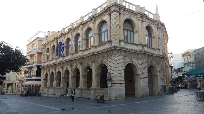
Overnight, the ship has cut through a strong storm out in the open sea and the resulting waves have thoroughly rocked me in my uncomfortable bed, so I’m feeling a bit bemused when I find myself on the pier in Heraklion, Crete’s largest city, at six thirty in the morning. Although that early, the sun is shining brightly in the completely clear sky and I already start feeling its warmth through my thick leather jacket. As I cannot leave the city without exploring its old centre, I go for a walk in its still deserted streets, among its Venetian heritage buildings and monuments, a basilica once turned into a mosque and a mosque which had undergone the reverse process of being transformed into an Orthodox church, until I find an open café, where I finally brace myself for an upcoming long riding day, over a breakfast of Greek pastry and strong coffee.

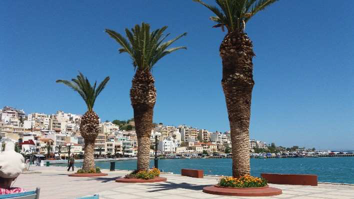
Later on, it’s rather difficult to find my way through the modern King Minos’ Labyrinth of narrow streets and alleys of newer Heraklion up to the coastline highway, but I eventually succeed in solving this challenge and ride eastwards for about 20 miles, then turn to a backroad which takes me to the wide sandy beach of Potamos, nearby Malia. Although this one is known for being a throbbing holiday destination, the still early hour and tourist season offer the whole of it just for myself, so I can quietly enjoy its fine golden sand and the wide panorama across the Aegean Sea for maybe half an hour. Further on, I ride another winding backroad, climbing the tall promontory of Cape Agios Nikolaos, through olive trees plantations and old stone windmills, which are the sources for Europe’s most wanted olive oil, before abruptly descending to the Mirabello Bay’s shore, in front of the 16th century Spinalonga fortress. Up next, I go back to the highway for a 30 miles long race, on large bends and tight hairpins uphill tall cliff-edges, then downhill to small villages in the bottom of deep valleys in between, up to Sitia, a small but chic town nested ashore a small round cove, where I have a coffee break in the shade of the tall portside palm trees.
I set off once again with replenished strength, cross the lunar landscape of a barren rocky plateau and descend on its other side, close to the island’s north-eastern tip, at Vai, the location of Europe’s sole natural palm trees grove, where I take a short walk on the nearby exotic looking golden beach. Although just the beginning of May, people are sunbathing here in large groups and I guess I’m an exotic presence myself, strolling through the thick fine sand in my boots and sturdy leather jacket! It’s already one o’clock by now and I continue my route, first towards Xerokampos, a secluded village on the just 12 miles long eastern shore, then westwards, along Crete’s southern coast to the Mediterranean Sea. This one is a sparsely populated area, the villages are small and quite distanced to one another and the relief alternates between fertile valleys nurturing olive groves and more barren rocky steep hills, exposed to a constant strong eastern wind. I pass by several deserted pebbly beaches, stop a couple of times to take some photos of this dramatic landscape – doing my best to avoid including the Greek Air Force facilities into these :) – and eventually I get to the town of Ierapetra, at about five thirty in the afternoon. I’m feeling tired as hell and I’d really call it a day, as I’ve already been riding for more than ten hours today, but I cannot find any reasonable hotel over here, so I’ve got to move on. Unfortunately, the nearest one of the kind I’m looking for is more than 80 miles away, in the Agia Galini resort, and my trusted companion Google Maps tells me it’s gonna be a two and a half hours long ride up there, due to the rugged terrain I’ve got to cover on my way. My morale is quite down right now, as that’s a bit too much for the condition I’m into, and this probably shows on my face, because, when I stop at a gas station to refuel and have a coffee, I also get a chocolate cream filled pretzel as a free bonus from the young girl at the counter!
The long way to Agia Galini starts with an endless series of bends and hairpins, steeply climbing the southern slope of the snow-capped crests above the Lasithi plateau; luckily, I’m almost alone on the road, so I can ride fast, in order to get sooner at the hotel and also force the adrenaline to keep me alert. The mountainous section is over in about 40 miles though, and now I ride along a flat corridor between two high mountain ridges and parallel to the sea, through cultivated fields and more olive groves, alternating each other in a disarming monotony. The villages are sparse, the traffic quite non-existent – the only vehicles I see are local farmers’ trucks, all of them featuring oversized wheels, out of fashion or necessity, I don’t know – and I’m getting gradually out of patience; eventually, right at the fall of dark, I get to the corridor’s western end, cross a surprisingly steep crest and descend on the shore, at Agia Galini, a cramped and crowded tourist settlement in total contrast to the bleak area I’m coming from. The Astoria Hotel’s looks and service suggest a much higher price than the one they’re charging me, but I don’t get to really enjoy that, as I hurry to have a usually late dinner and a couple of beers, then fall sound asleep as soon as I’m back in my room. I guess I’ve pushed my limits a bit too much today!
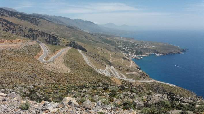
The western half of Crete’s southern coastline is dominated by the Lefka Ori mountain range, whose slopes are plunging into the Mediterranean Sea so steeply that most of the tiny villages hidden inside small rocky coves aren’t connected to one another by any coastal road; the sole option to reach them is along several deep and narrow spectacular canyons running from north to south, except for Loutro and Agia Roumeli, which can only be reached by sea! The central part of the massif is basically unpassable, being barren and rocky, actually one of the very few true desert areas in Europe, and its 6,500+ ft. high summits are still covered in snow this time of the year, so my plan for today is to make a detour around its northern slopes, climb to the Omalos plateau, then descend once again to the shore at Palaiochora, close to the island’s south-western tip.
I set off in the morning for about 20 miles onto the main road to Rhetimno, then I turn left through the Kourtaliotiko Gorge, a limestone area where the torrents had carved a wild and spectacular canyon. The narrow coastal road further on makes me feel as I’m riding an endless montagne-russe, passing by authentic villages hanging from the mountains’ steep slopes and picturesque small ports laying beside narrow strips of golden sand beaches. The views are absolutely charming and I’m tempted to stop for photos at every turn, so it takes me almost three hours to get to Hora Sfakion, just 60 miles away from the place I’ve slept last night. I take a break in a café featuring a shady terrace suspended above the local bay’s crystal-clear water, then I engage the fabulous hairpins towards the village of Anopolis, climbing 2,000 ft. altitude difference in just 7 miles! Even if I usually don’t ride the same road back and forth, this time I have to turn back, as this road it’s a dead end just a few miles farther, but the upside of this thing is I get to enjoy the hairpins once again, this time in a more relaxed mood. Back to Hora Sfakion, I turn left towards the island’s northern shore and discover another series of hairpins, almost equally spectacular to the ones behind, which takes me above the Imbros Gorge, another deep canyon which grooves the rocky mountain slope. After I pass the crest, I descend in large bends to the town of Vryses, then take the main highway up to Chania’s outskirts; over here, I exit once again to a backroad and start climbing back the massif, heading to the same southern shore I rode along during the most part of the day.
The route I’ve chosen passes through one more canyon, Therisos, milder and greener than the ones before, at whose end there lays the namesake village, where the valley closes in front of a steep slope; it seems there’s no way out, but the much narrower road ahead continues climbing in almost impossible tight hairpins, up to the base of a vertical rocky wall, then clings above a seemingly bottomless abyss, to eventually reach the hamlet of Zourva, featuring tiny decrepit houses, many of them looking to have been abandoned by their former owners. Up next, I descend a bit along a broader valley, where the tarmac is disappearing several times as a result of recent floods and landslides, then I start climbing again through dense pine woods which are covering somewhat milder slopes. As I’m getting closer to the snow-capped crests, the temperature drops dramatically and, while just half an hour earlier I was melting in the afternoon heat, now I start feeling my fingers are freezing and my helmet’s visor is constantly being steamy. Eventually, at about five in the afternoon, I get into a strange, flat and deserted area, surrounded by foggy tall summits all around: the Omalos plateau. Moreover, as if the freezing cold hadn’t been enough, it suddenly starts raining in big drops which threaten to soak me in no time. I’m hurriedly looking for some shelter and I’m lucky to find it real soon at a hut restaurant, where a group of Greek tourists are having sort of a party inside! I’m not really into joining them, so I sit outside, on the covered terrace, and warm myself up with a coffee as hot as hell.
Half an hour later, the rain stops and it’s time to move on. During the forced break I took earlier, I booked online a room in a hotel in Palaiochora, on the seashore, which is – apud Google Maps – 35 miles and one and a half hour (?!) away, which means I’ve got to hurry up if I don’t want to ride the last part of the route in the dark. Honestly, I don’t, so I go on as fast as the road lets me to, which actually is quite slow, due to the endless bends, ups and downs. There are so many curves that, as I’ll have noticed later on, I completely lose my orientation sense; about an hour after I left the plateau, I see a road sign indicating some I-don’t-know-how-many miles up to Chania! Chania?!!! That’s the place where I’m coming from, on the northern shore, while my destination is on the opposite one. I stop, take a closer look at the map and feel the whole sky is falling onto my head: I’m heading to the wrong direction for about half an hour now! More serious than the amount of time I’ve lost is the fact I actually don’t realise where exactly I’ve missed a turn, as I simply cannot remember passing by any crossroads which I haven’t paid the appropriate attention to. Now I don’t have any other option than turn back and try to find the right way south; and, when I’m just a few miles away from back to Omalos, I see on my right a poor road which seems to descend on the correct side of the mountain. I look once again to the map and yes, this is where I should have turned left in the first time, yet, to my consolation, there’s no sign pointing anywhere and the road itself looks more like a decent fire track than a proper means to get to any human settlement.
The unexpected detour I took earlier, as well as the incredibly narrow and ever twisting road I’m riding onto, slow me down quite a lot, so I eventually get to Palaiochora after eight o’clock, when the sun is already setting into the sea. I leave my bike and luggage at the hotel, then I hurry for a walk in the streets of this strategically placed townlet, ontop of a rocky promontory flanked by the sea on two of its sides and overlooked by the ruins of a Venetian fortress on the third one. I conclude the evening in a family run taverna with super tasty traditional dishes, then go to bed chewing a dilemma regarding my tomorrow’s route to the superb Elafonissi beach: shall I make an overly sinuous detour on the tarmac road inlands, or should I push my luck onto an off-road track somehow parallel to the seashore? I hope the night will be a wise advisor to me regarding this matter!
Right before I leave the hotel in the morning, I take one more glimpse at the map and my decision is clear: I’m in no mood to take a 30 miles detour to the centre of the island, especially that I’ll have to ride half of this route back in the opposite direction afterwards, therefore I’ll head to Elafonissi on the off-road track, although that’s not even marked as a road on my map, but it’s only visible in the satellite view. The first part of this section is on tarmac, albeit I don’t encounter any traffic onto it; first I ride along the coast to Gialos, a hamlet surrounded by widespread makeshift greenhouses – due to its hot, North African climate, Crete’s southern coastline area provides year-round vegetable crops, then I climb the mountain’s slope right through the kingdom of goats! On both sides of the road and also in the middle of it, here and there, are grazing or laying down hundreds of goats, living half freely and not even looking bothered by my appearance; on the other side, though, I don’t feel quite at large among them, as the road is covered in a true carpet of faeces and the obtrusive piddle smell is really overwhelming. I try to hold my breath as long as I’m able to and I eventually rest easy several miles farther, when this nightmare ends, in the outskirts of the village of Sklavopoula. Over here, nearby a small church and old more or less abandoned stone houses, I see a road sign pointing left to Elafonissi, just 8 miles away, and I hastily jump to the conclusion the road must be passable and the unpaved section isn’t even too long!
Indeed, I ride for about two miles onto a narrow and rocky track, which is winding along the steep slope, level enough not to raise too great technical difficulties to me. The view across the surreal blue sea below is priceless and there’s absolutely no soul in sight. I pass by a small way-side cross – an important clue that I’m still on the right path, in Balkan culture – erected in a windy saddle, then I climb towards a long and sharp crest and, right when I cross over its edge and start descending to a deep, steep walled valley, my smile freezes onto my lips: the road’s condition changes dramatically and I slide downhill with the brake lever fully pressed and my feet dragging down on an unstable layer of loose rocks, while I’m trying to do my best in dodging the big and sharp ones which threaten to cause a flat tyre I would by no means be able to fix here to my bike. On the valley’s draught bottom, the track’s difficulty level seems to ease down a bit, giving me the opportunity to have a much-needed orientation and hydration break, but I still have to cross one more crest, then engage the final descent to the seashore, onto a series of tight hairpins which I find equally difficult to the section behind. The final glorious ending of my short off-road adventure takes place in a 180 degrees turn in an extremely steep downhill gradient, where I brake hard and sudden in order to avoid getting too close to the track’s edge, which is opening freely to the abyss below, and I obviously drop the bike sideways! Luckily, this happens at very low speed and while my feet are already on the ground, so there’s no damage at all, except maybe to my ego; the downside of this mishappen is the bike falls down on its right side, exactly the harder way to stabilize when I bring it upright!
At eleven thirty – so it took me more than an hour to ride those just 8 miles of off-road track!, I eventually get to Elafonissi, leave my bike at the farthest point the thick sand allows me to advance to and walk to the beach. The fabulous view in front of me is hard to describe in plain words: a long and narrow strip of pinkish white sand, lined by intense green pine trees and huge cacti, is connecting the shore to a small rocky island and, on its both sides, there stretches the calm turquoise water, no more than two feet deep up to far away to the open sea. This is how the paradise must look like, I guess! I walk to and fro along the beach, then lay down on the sand for a while, as I don’t really want to leave this amazing place too soon. When I eventually get back to the bike, I ride no more than a couple of hundred yards, then stop for a frappe at the suggestively named Panorama Tavern, located in a vantage point ontop of a sand dune, and I admire for some more time the views across what must be the most remarkable landmark of my entire journey!
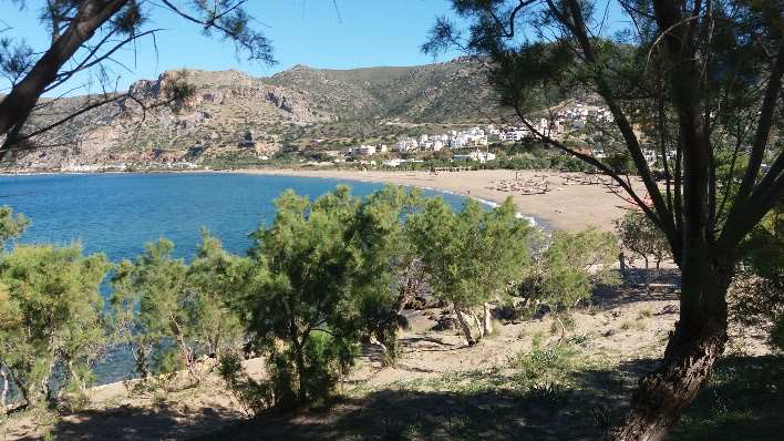
As Crete’s overall contour is somehow rectangular, the natural sequel of my today’s route is northwards, along its western shore, up to the resort of Phalasarna. Due to the rugged landscape it has to cross, the road runs at a certain distance from the coastline, albeit short enough to maintain the visual contact to it, more or less constantly winding along an imaginary level curve drawn upon the mountains’ steep slopes. Nevertheless, unlike the previous section I’ve ridden this morning, this one is featuring less rocks and more vegetation, which proves to be quite a drawback at some point ahead of the Kampos village, where I find the road completely blocked by an enormous barrier made out of dirt, rocks and fallen trees, which must have appeared due to a recent landslide! Fortunately, while I’m standing at the roadside and studying the map for a convenient detour option, a local comes out of nowhere and points me to a precarious track nearby, which is first descending through the olive trees groves to the shore, runs parallel to it for a few miles, then brutally climbs back along a draught valley up to the main road. I don’t lose too much time by making that emergency detour, so, after taking a short break beside the wild pebbly beach at Sfinari later on, I get to the wide sandy beach of Phalasarna at about two thirty in the afternoon. From this place, there are just 30 miles to Chania, my destination for today, so I’ve got time for a rich seafood lunch over here, large enough to have my fill until tomorrow morning!
In Chania, Crete’s second largest city, I park my bike beside the 16th century defence walls and stroll in the narrow and crowded streets downtown, around the old Venetian pier. I go shopping for some souvenirs, linger on a coffee and cake at a seafront café until the fall of dark, when I ride the few miles to Souda, at the ferry terminal. I take advantage of arriving here quite early and retreat to an empty corner of the large parking lot, in order to clean and lubricate my bike’s transmission chain, as it kept annoying me with a harsh, metallic noise for the last days, then I embark the ship and wait beside a couple of beers for the departure time to come. My Cretan tour is over and now I’m facing the long and boring ride home.

Heraklion
Heraklion

Cape Agios Nikolaos

Mirabello Bay
Sitia

Vai beach
Hora Sfakion

The Imbros Gorge

The Therisos canyon
Palaiochora

Elafonissi beach

Phalasarna beach

Chania
The prosaic Greece & Bulgaria reloaded. 770 miles
The busy port activity and the crowded morning traffic in the Athens-Piraeus metropolis are in blatant contrast to Crete’s relaxed, vacation spirit and make me feel the interesting part of my journey is rather over already. I’m ahead of a long and boring way home, so I don’t have much time to lose, therefore I set off in a steady pace ever since I got off the ship. I head north-west, taking the old national road to Thiva, Livadia and further on to Lamia instead of the motorway, facing sparse traffic and unexpected low temperature, although the snow-capped Parnassus Mountain I see in the distance suggests that would be quite normal. At about eleven o’clock, I take a short detour from my route, in order to visit the Thermopylae Memorial, which is marking the spot of the famous battle between the King Leonidas’ 300 Spartans and the powerful Persian invading army. Aside from the sensation that the monument’s overall appearance doesn’t match the event’s importance to the ancient European history, the fact which strikes me the most is the discrepancy between the historical sources’ reports and the terrain reality: the Greeks’ strategical choice for this specific place to resist the attack had been made on behalf of the extremely narrow strip of land between the mountain and the sea, yet the latter is anything but close over here. Though, according to the info displayed on the memorial plaque, it seems the present coastline is more than two miles farther from its initial position some 2,500 years ago?!
Past Lamia, I ride for two more monotonous hours onto the national road, across the vast plain of Thessaly up to Larissa, where I finally take the motorway up north. Fast-forward, 150 miles farther, after I pass by Katerini, Thessaloniki and the Strymonian Gulf, I stop at a gas station to evaluate my options for tonight; as much as I’d wish to get closer to the Bulgarian border today, in order to shorten my route tomorrow, the only reasonable choice seems to be the city of Kavala, where I’ll get to past seven in the evening. The Akropolis Hotel has the advantage of being located right in the city centre, within walking distance to the seafront promenade and tavernas, but everything over here – including the landlady :) – is heritage of the past century, and I mean its very beginning! After all, though, I’m too tired to complain about that and I know I’m going to have a sound sleep anyway, so I can get over it without much fuss.
Regarding the last day and one more quick run across Bulgaria, there’s not much to say about. I wake up really early, while both the hotel and also the entire city are still absorbed in the weekend’s morning silence, have a coffee on a bench facing the fishing harbour’s pier, then set off towards Komotini and the border crossing at Makaza. Up next, I take the usual transit route by the cities of Haskovo, Stara Zagora and Veliko Târnovo, then switch the last 30 miles long busy section ahead of Ruse for the much quieter parallel backroad through the towns of Borovo and Dve Mogili, to arrive at the Romanian border at about four in the afternoon. I take the delight of overtaking the long line of cars waiting to pay the Danube bridge toll – free passage for motorcycles over here – and one hour later I’m eventually home. I’m going to rest this evening, but tomorrow morning I’ll be already starting to make plans for my next tour!

The Thermopylae Memorial

Kavala


Comments